Privacy statement: Your privacy is very important to Us. Our company promises not to disclose your personal information to any external company with out your explicit permission.
BD/GPS (or GPS/GLONASS) dual-mode navigator is a navigation and positioning device based on navigation and positioning technology, GIS, wireless communication technology, and advanced technologies such as computer software and network. The navigator can display the dynamic position (longitude and latitude), time, status and other information of the carrier on the screen, navigate according to the user's needs, and simultaneously transmit the short message by position or other information through the GPRS wireless communication link. The navigator has the characteristics of accurate navigation and positioning, reliable performance, flexible application and easy operation. In addition, it also has functions such as video playback, music playback, e-books, games, etc.
This article refers to the address: http://
System composition and workflow
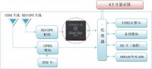
The core positioning chip used in this system is the multi-mode compatible navigation positioning chip OTrach-32 independently developed by Oriental Lianxing Company, which can receive BD, GPS and GLONASS satellite signals at the same time. The high-performance architecture's 32-channel design enables fast signal capture. At the same time, the design of the navigation and positioning algorithm is completed, and it is integrated into the Window CE system by means of a driver. At the same time, the development and integration of electronic maps and navigation algorithms and application software are completed.
The processor uses the S3C2440 chip based on the ARM 920T core structure, with a clock speed of up to 530 MHz, SDRAM of 64 MB, Flash of 32 MB, external SDRAM and NANDFlash. The Window CE5.0 operating system is ported on it.
System composition diagram

The general workflow of the navigator is as follows: First, the navigator obtains the specific geographical location information of the carrier and other ancillary information (such as driving speed and time) through the satellite navigation positioning chip (OTrack-32) and related algorithms. Then, through the map in the built-in storage device, the map portion corresponding to the current location is displayed on the color display screen, and the state of itself (such as speed, time, what kind of message is received, etc.) is displayed. By setting up the GPRS communication module, you can realize the communication connection with the Internet or other terminals.
The dual-mode navigator can use any Windows CE 5.0-based navigation software on the market, such as Kay LiDE, Dao Dao Tong, Gao De and so on. The navigation software is stored in the SD card and does not require special installation. Different navigation software can be used by replacing the SD card.
Features
The dual mode navigator has the following advantages:
◆ BD/GPS (or GPS/GLONASS) dual system navigation and positioning to make positioning more accurate, safe and reliable;
◆ Adopting independent intellectual property positioning chip, hardware circuit and software are all localized, technical support and product upgrade are more secure;
◆ Suitable for a variety of carriers, with excellent dynamic performance;
◆ Powerful, integrated GPRS communication function and a variety of entertainment and leisure functions, using 4.3-inch touch screen, clear display;
◆Using Windows CE operating system, large-capacity SD card, easy to replace a variety of maps.
in conclusion
After long-term application test, the functions and technical indicators of the navigator meet the design requirements, and have the characteristics of accurate navigation and positioning, reliable performance, flexible application and easy operation. The internal use of BD / GPS / GLONASS multi-mode compatible satellite navigation chip OTrack-32, with the same or better than the foreign navigation chip technical indicators, and has been widely used since 2008. The satellite navigation device using the chip can be applied to vehicles, navigation, aviation, and other places such as personal travel, wild adventure, and the like that require navigation. Its excellent performance will surely show extraordinary quality.
June 28, 2024
Mail an Lieferanten
June 28, 2024

Privacy statement: Your privacy is very important to Us. Our company promises not to disclose your personal information to any external company with out your explicit permission.

Fill in more information so that we can get in touch with you faster
Privacy statement: Your privacy is very important to Us. Our company promises not to disclose your personal information to any external company with out your explicit permission.